
First 2021 Atlantic hurricane season forecast: active season expected
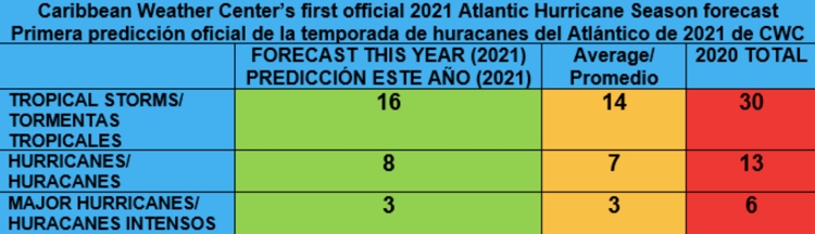
Caribbean Weather Center has finished its first forecast for the 2021 Atlantic Hurricane Season (tenth year forecasting since 2012) and calls for an active season with a total of 16 tropical storms, 8 hurricanes and 3 major hurricanes. As always with a margin of error of +-2. As of now, compared to the 2020 hurricane season, they forecast that it will be less active than the record breaking 2020 hurricane season.
Why do they think it will be less active than last year?
The main reason is because for this year, they do not see the same conditions and ingredients like seen last year that led to a hyperactive record-breaking year. We will probably not see either a La Niña or El Niño during most of the season, with Neutral conditions in place during most of the season in combination with some favorable factors. Some recent analog years used for this forecast are within others the 1996, 2008 and 2011 seasons. Those were active seasons and this one has similarities to those. Still, we have several months till we get to the peak of the season, so changes are still possible, but this is a clear indication that we must be prepared just in case.
The specific reasons why we think it is going to be an active season:
1. The expected average to above average sea surface temperatures across the Atlantic basin, with warm to very warm sea surface temperatures across the subtropical area of the Atlantic. Warm sea surface temperatures feed tropical cyclones and provide these with fuel to develop and strengthen.
2. The presence of Neutral conditions during the whole season or during most of the season. This would generally lead to favorable conditions across the Atlantic basin with around average wind shear.
3. Around average wind shear as stated above, as the wind shear will vary in intensity during the season and be favorable over some places and less favorable over others during different periods of the season, but overall, it will be sufficiently favorable for development of cyclones, mostly during the peak of the season.
4. We also expect to a certain degree generally lower pressures across the Atlantic basin during the season, also leading to an upward motion of air (instability) which also enhances the formation of tropical cyclone development. This means that we will have a weaker than average high pressure during the season which is related with the expected subsequent episodes of a negative phase of the NAO (North Atlantic Oscillation) that is forecasted which will lead to weaker trades also promoting a warmup of the sea surface temperatures across the tropical Atlantic during mostly the peak months of the season.
5. An active monsoon (also enhanced by the warm phase of the AMO) across Africa leading to robust/ strong /active tropical waves across the Atlantic basin (this is currently predicted by the models). However, we do expect outbreaks of masses of Saharan dust during the coming months until the end of July, when it should decrease as tropical waves get stronger and the ITCZ (Intertropical Convergence Zone) moves to the north leading to more rain across the Sahel region and decreasing the amount of dust that gets blown into the air to be transported to the Atlantic basin. But as always, with the presence of Saharan dust, also comes the dry air, which will also be present occasionally throughout the season.
6. One aspect that will not be very significant this season but may gradually increase during the season itself, is the oceanic heat content (energy for tropical cyclones) located at the surface down to the sub-surface of the ocean. Since the strong tropical systems (major hurricanes, within others) absorbed a huge amount of stored oceanic heat content across the western Caribbean last year, which was stored for years because of the lack of significant systems over that region, now we see very little oceanic heat content across the Caribbean, a factor that when there is lots stored, adds to the development and intensity of the tropical cyclones. But as the ocean will be warming up in the subsequent months (adding more oceanic heat content) as a warm phase of the AMO (Atlantic Multidecadal Oscillation) is forecasted during the season and that enhances warmer than average sea surface temperatures over the Atlantic basin, this will favor the development of tropical cyclones at some point.
• One aspect to point out is that in the past, we have seen an early start to hurricane seasons after a La Niña year because conditions are already more favorable than on average due to its recent presence, which means that also this year, the season might start earlier than on average (earlier than June 1st).
• Another aspect to point out is that this year, we expect a weaker high pressure than last year, opening the door to the tropical cyclones to move more easily towards the northwest away from the Caribbean and even from land (what we call a recurve), so we will not have a strong and dominant high pressure throughout the season to push all or most of the systems towards the west into the Caribbean. Still, the Caribbean will need to watch the systems at a lower latitude as those could manage to enter the Caribbean, mostly the northeastern Caribbean.
Areas to mostly watch this season for potential impacts from tropical cyclones, will be the Gulf of Mexico, the southeastern and eastern USA, and the northeastern Caribbean. The mentioned areas may likely have to deal with one to several tropical cyclones this season as the conditions there will be favorable. That would mean that again, some systems will develop close or move to land and this year, unfortunately, the United States and the northeastern Caribbean are the areas to watch. Caribbean Weather Center also expect several systems to recurve towards the open waters of the ocean as mentioned above and to form over the subtropical Atlantic, which means that the island of Bermuda is also an area to watch.
Caribbean Weather Center keeps on posting updates on the season, as changes are always possible, and will update this forecast if necessary.
- Traveling abroad?
- Curaçao Seeks ‘Level Playing Field’ for Local Airlines
- First Edition of Bonaire by Night on Friday, August 2
- Edsel Winklaar appointed interim director at Selibon N.V.
- Bonaire Human Rights Organization advocates for Bonaire in Azerbaijan
Meer News
-
 Advertisement
Traveling abroad?
-
 Airlift
Curaçao Seeks ‘Level Playing Field’ for Local Airlines
-
 Events
First Edition of Bonaire by Night on Friday, August 2
-
 Bonaire
Edsel Winklaar appointed interim director at Selibon N.V.
-
 Airlift
Aruba speaks to Gol Airlines about Brazil market expansion
-
 Healthcare
1,500 healthcare professionals trained in acute care by Caribbean Health Academy
-
 St. Eustatius
Empowering Girls: Mega D Youth Foundation hosts inspiring session with Miss Mature Shomica Griffith
-
 Saba
SabaSaba executes climate change survey among residents
Meer News
-
Advertisement
Traveling abroad?
-
Airlift
Curaçao Seeks ‘Level Playing Field’ for Local Airlines
-
Events
First Edition of Bonaire by Night on Friday, August 2
-
Bonaire
Edsel Winklaar appointed interim director at Selibon N.V.
-
Airlift
Aruba speaks to Gol Airlines about Brazil market expansion
-
Healthcare
1,500 healthcare professionals trained in acute care by Caribbean Health Academy
-
St. Eustatius
Empowering Girls: Mega D Youth Foundation hosts inspiring session with Miss Mature Shomica Griffith
-
Saba
Saba executes climate change survey among residents